Asia's biggest water tower is quietly draining — and it's not the part you'd expect
A peer-reviewed satellite study finds High Mountain Asia losing 24.2 billion tonnes of groundwater a year, concentrated in the densely populated basins the paper says over 430 million people depend on — even as some interior regions gain water.
What happened. A study published in Environmental Research Letters on January 2, 2026 — and drawing renewed attention this month after ScienceDaily covered it on August 20 — found High Mountain Asia lost groundwater at a net rate of 24.2 billion tonnes a year between 2003 and 2020. The team, led by Shudong Wang at the Chinese Academy of Sciences' Aerospace Information Research Institute, combined satellite gravity data, Earth-system modeling, and machine learning, then validated the results against readings from real monitoring wells.
What it means. About 69% of High Mountain Asia — the mountain and plateau system spanning the Himalayas and Tibetan Plateau that feeds Asia's major rivers — lost groundwater over the study period. The losses weren't even. The Ganges-Brahmaputra basin alone accounted for more than half the total depletion, at 12.8 billion tonnes a year, with the Amu Darya (3.3 billion tonnes/year) and Tarim (2.1 billion tonnes/year) basins also declining. Meanwhile, sparsely populated interior basins of the Tibetan Plateau that drain internally rather than into major rivers gained about 3.51 billion tonnes a year. The paper describes the losing basins directly as "densely populated and irrigated" and "densely populated and agriculturally intensive" — this isn't an editorial characterization, it's the study's own language.
Why it's happening. The researchers used explainable-AI attribution methods to separate the causes: climate factors (precipitation, temperature, radiation) explained about 47% of the change; glacier and permafrost melt about 15%; human groundwater extraction up to 38% in the hardest-hit basins. It's not purely a climate story or a human-consumption story — both are layered on top of each other in the same basins, which the paper describes as suffering "persistent groundwater overexploitation."
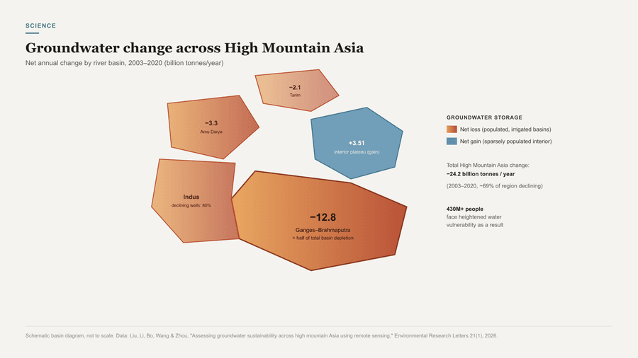
Why it matters. This shows up in the ground, not just in models: 80% of monitored wells in the Ganges-Brahmaputra and Indus basins showed statistically significant declining trends. The paper estimates more than 430 million people face heightened water vulnerability as a result.
What's next. The paper explicitly says these hydrological systems are "approaching a tipping point under continued warming" — its own term, not an outside characterization. Its most counterintuitive finding is the timeline: increased glacier melt is projected to temporarily buffer the decline through roughly the 2060s. But the paper is direct that this buffer is "temporally limited and unsustainable" — once glacier contribution diminishes later this century, with glaciers projected to lose up to half their volume, groundwater depletion is "projected to accelerate once again."
Who's affected. Farmers and cities across the Ganges-Brahmaputra, Indus, and Amu Darya basins — spanning India, Bangladesh, Pakistan, and Central Asia — are most exposed. The paper's projections depend heavily on whether current extraction rates continue.
Sources (2)
About the author
Muhammad ZahidFounding Editor, BriefLookout
Muhammad Zahid is the founding editor of BriefLookout, an independent publication focused on explaining what happened, what it means, why it matters, and what could happen next. He works across editorial strategy, research, and the systems behind BriefLookout to make complex developments easier to understand.
More from Muhammad Zahid →Related reading
Your brain's immune cells were supposed to be sealed in for life. In humans, blood cells start joining them at middle age.
BriefLookout · 26 Aug 2026 · 4 min read
Physicists didn't recreate the Big Bang. They caught a nucleus giving away its shape.
Muhammad Zahid · 25 Aug 2026 · 5 min read
NASA's next flagship telescope is launching nine months early. That's the strangest thing about it.
Muhammad Zahid · 24 Aug 2026 · 4 min read